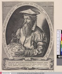
"Gerardus Mercator (/dʒɪˈrɑːrdəs mɜːrˈkeɪtər/;[a][b] 5 March 1512 – 2 December 1594)[c] was a 16th-century geographer, cosmographer and cartographer from the County of Flanders. He is most renowned for creating the 1569 world map based on a new projection which represented sailing courses of constant bearing (rhumb lines) as straight lines—an innovation that is still employed in nautical charts.
Mercator was one of the pioneers of cartography and is widely considered the most notable figure of Netherlandish school of cartography in its golden age (approximately 1570s–1670s). In his own day, he was a notable as maker of globes and scientific instruments. In addition, he had interests in theology, philosophy, history, mathematics and geomagnetism. He was also an accomplished engraver and calligrapher." - (en.wikipedia.org 29.03.2021)


