museum-digital
CTRL + Y
en
Vogtlandmuseum Plauen [L 695]
Landkarte (Vogtlandmuseum Plauen CC BY-NC-SA)
Provenance/Rights: Vogtlandmuseum Plauen (CC BY-NC-SA)
1 / 1 Previous<- Next->

Landkarte

Contact Cite this page Data sheet (PDF) Canonical version (record) Calculate distance to your current location Mark for comparison Graph view

Description

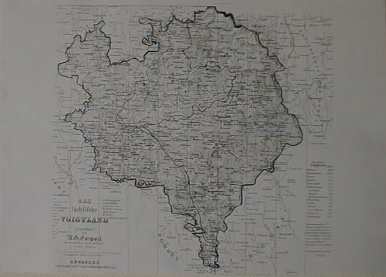
Die Landkarte zeigt das sächsische Vogtland, gezeichnet im topographischen Charakter, Grenzen coloriert, mit Eisenbahnlinien versehen, ungeben v. Teilgebieten Böhmens, Bayerns, Reussischem und Erzgebiergskreis. Oberes Drittel der Karte mit 2 Längen-Profiel-Zeichnungen; unten links Zeichenerklärung Titel und Meilenzeiger; unten rechts Tabelle mit Einwohnerzahlen größerer Städte des Vogtlands und Gesamteinwohnerzahl, Maßstab: Geographische Meilen 15 auf 1 Grand
Karte (Sächsisches Vogtland)

Material/Technique

Papier / gedruckt (Lithographie) & coloriert

Measurements

H: 66,50 & 69,0 cm / B: 46,5 & 48,0 cm

Vogtlandmuseum Plauen

Object from: Vogtlandmuseum Plauen

Das Vogtlandmuseum Plauen beherbergt in seinen Räumen die umfangreichste Sammlung zur vogtländischen Regionalgeschichte und Kultur. Die...

Contact the institution

[Last update: ]

Usage and citation

The textual information presented here is free for non-commercial usage if the source is named. (Creative Commons Lizenz 3.0, by-nc-sa) Please name as source not only the internet representation but also the name of the museum.
Rights for the images are shown below the large images (which are accessible by clicking on the smaller images). If nothing different is mentioned there the same regulation as for textual information applies.
Any commercial usage of text or image demands communication with the museum.