museum-digital
CTRL + Y
en
Deutsches Damast- und Frottiermuseum Ortsgeschichte [1956-1438]
Karte von Großschönau, 1732 (Deutsches Damast- und Frottiermuseum CC BY-NC-SA)
Provenance/Rights: Deutsches Damast- und Frottiermuseum (CC BY-NC-SA)
1 / 1 Previous<- Next->

Karte von Großschönau, 1732

Contact Cite this page Data sheet (PDF) Canonical version (record) Calculate distance to your current location Mark for comparison Graph view

Description

Laut Signatur wurde diese Karte von Großschönau im Jahr 1732 von Carl Friedrich Zürner, Bruder des berühmten Kartographen Adam Friedrich Zürner (1679-1742), aufgenommen.

Material/Technique

Papier

Deutsches Damast- und Frottiermuseum

Object from: Deutsches Damast- und Frottiermuseum

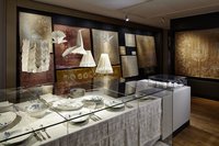
Das Deutsche Damast- und Frottiermuseum Großschönau bewahrt die einzigartige Textilgeschichte des Ortes, die von überregionaler Ausstrahlungskraft...

Contact the institution

[Last update: ]

Usage and citation

The textual information presented here is free for non-commercial usage if the source is named. (Creative Commons Lizenz 3.0, by-nc-sa) Please name as source not only the internet representation but also the name of the museum.
Rights for the images are shown below the large images (which are accessible by clicking on the smaller images). If nothing different is mentioned there the same regulation as for textual information applies.
Any commercial usage of text or image demands communication with the museum.