museum-digital
CTRL + Y
en
Museum Europäischer Kulturen [I (62 I) 216/1986,5]
http://www.smb-digital.de/eMuseumPlus?service=ImageAsset&module=collection&objectId=569108&resolution=superImageResolution#4511498 (Museum Europäischer Kulturen, Staatliche Museen zu Berlin CC BY-NC-SA)
Provenance/Rights: Museum Europäischer Kulturen, Staatliche Museen zu Berlin / Fotograf unbekannt (CC BY-NC-SA)
0 / 1 Previous<- Next->

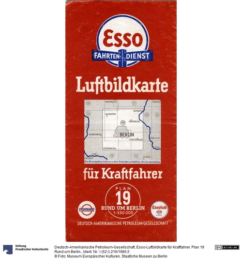
Esso-Luftbildkarte für Kraftfahrer. Plan 19 Rund um Berlin.

Contact Cite this page Data sheet (PDF) Canonical version (record) Calculate distance to your current location Mark for comparison Graph view

Description

Hochformat. Faltkarte im Maßstab: 1: 250 000. für Kraftfahrer. Auf der aufgeklappten Innenseite die Straßenkarte mit der Einzeichnung der Reichsstraßen,, Landstraßne und Eisenbahnlinie.
Auf den aufgeklappten Außenseiten u.a. ein s/w Stadtplan mit Sehenswürdigkeiten der Zeit, z.B. Museumsinsel, Siegessäule, Reichssportfeld und Horst Wessels Grab. Dazu Informationen "Rund um Berlin".

Material/Technique

Papier, Druck

Measurements

Höhe x Breite: 24 x 11,3 cm zusammengeklappt

Links / Documents

Created Created
1930
Bruckmann Verlag
Munich
Published Published
1930
German-American Petroleum Company
1929 1941
Museum Europäischer Kulturen

Object from: Museum Europäischer Kulturen

Das MEK sammelt und bewahrt Materielle und Immaterielle Kultur aus ganz Europa und erhält sie für die Zukunft. Die kulturellen Ausdrucksformen...

Contact the institution

[Last update: ]

Usage and citation

The textual information presented here is free for non-commercial usage if the source is named. (Creative Commons Lizenz 3.0, by-nc-sa) Please name as source not only the internet representation but also the name of the museum.
Rights for the images are shown below the large images (which are accessible by clicking on the smaller images). If nothing different is mentioned there the same regulation as for textual information applies.
Any commercial usage of text or image demands communication with the museum.