museum-digital
CTRL + Y
en
"dc-r" docu center ramstein Schriftgut [DCR2012_0037_06]
Landkarte, Afghanistan Summer 2010 (dc-r docu center ramstein RR-F)
Provenance/Rights: dc-r docu center ramstein (RR-F)
1 / 1 Previous<- Next->

Landkarte, Afghanistan Summer 2010

Contact Cite this page Data sheet (PDF) Canonical version (record) Calculate distance to your current location Mark for comparison Graph view

Description

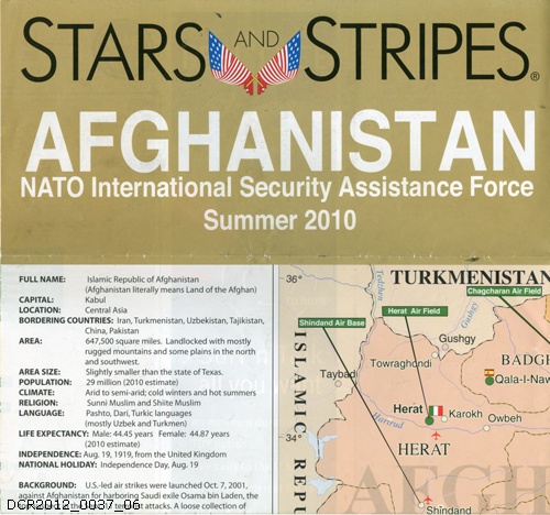
Landkarte von Afghanistan mit der Kennzeichnung der verschiedenen Camps, Air Fields, Air Bases und FOB, die sich über das Land verteilen. Links Informationen zum dem Land (Größe, angrenzende Länder, Religion, Population, Klima, Sprache etc.) Oben Aufzählung der ISAF Truppen mit jeweiliger Landsflagge, rechts und unten Werbeeindrucke.
Textaufdruck Vorderseite: STARS AND STRIPES AFGHANISTAN NATO International Security Assistance Force Summer 2010

Material/Technique

Papier, Druck

Measurements

H 59cm; B 84 cm

"dc-r" docu center ramstein

Object from: "dc-r" docu center ramstein

„Ramstein, Germany“ ist durch seinen US-Flugplatz weltweit ein Begriff. Das benachbarte Kaiserslautern kennt man in der Welt als „K-Town“. Seit bald...

Contact the institution

[Last update: ]

Usage and citation

The textual information presented here is free for non-commercial usage if the source is named. (Creative Commons Lizenz 3.0, by-nc-sa) Please name as source not only the internet representation but also the name of the museum.
Rights for the images are shown below the large images (which are accessible by clicking on the smaller images). If nothing different is mentioned there the same regulation as for textual information applies.
Any commercial usage of text or image demands communication with the museum.