museum-digital
CTRL + Y
en
Museum Baruther Glashütte Glaskultur [180030]
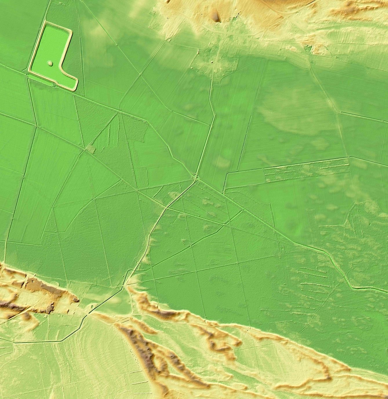
Grafik Baruther Urstromtal (Amt für Geobasisdaten CC BY-NC-SA)
Provenance/Rights: Amt für Geobasisdaten / Amt für Geobasisdaten Potsdam (CC BY-NC-SA)
1 / 1 Previous<- Next->

Grafik Baruther Urstromtal

Contact Cite this page Data sheet (PDF) Canonical version (record) Calculate distance to your current location Mark for comparison Graph view

Description

Die laserscan basierte Luftbildaufnahme eines Abschnitts des Baruther Urstromtals zwischen Glashütte und Radeland/Dornswalde ist eine computergestützte Bearbeitung, die Häuser und Bewuchs "herausrechnet". Es zeigen sich neben äolisch geprägten Dünen auch anthropogene geologische Veränderungen wie das Anschlussgleis vom Bahnhof Klasdorf nach Glashütte (Bau 1875), die Schürgrube des Siemensgenerators (Bau 1861) oder das "Schöpfwerk" (Meliorationsbauwerk, um 1970). Die Aufnahme ist eine Quelle zur Veranschaulichung der anthropogenen geologischen Veränderungen im Anthropozän.

Material/Technique

Laserdruck, laserscanbasierte Luftaufnahme

Measurements

ca. 50 x 50 cm

Museum Baruther Glashütte

Object from: Museum Baruther Glashütte

Das Museum Baruther Glashütte ist spezialisiert auf Glas- und Technikgeschichte. Es ist ein authentischer Standort der Industriekultur in der...

Contact the institution

[Last update: ]

Usage and citation

The textual information presented here is free for non-commercial usage if the source is named. (Creative Commons Lizenz 3.0, by-nc-sa) Please name as source not only the internet representation but also the name of the museum.
Rights for the images are shown below the large images (which are accessible by clicking on the smaller images). If nothing different is mentioned there the same regulation as for textual information applies.
Any commercial usage of text or image demands communication with the museum.