museum-digital
CTRL + Y
en
Potsdam Museum - Forum für Kunst und Geschichte Landkarten [L-78-4]
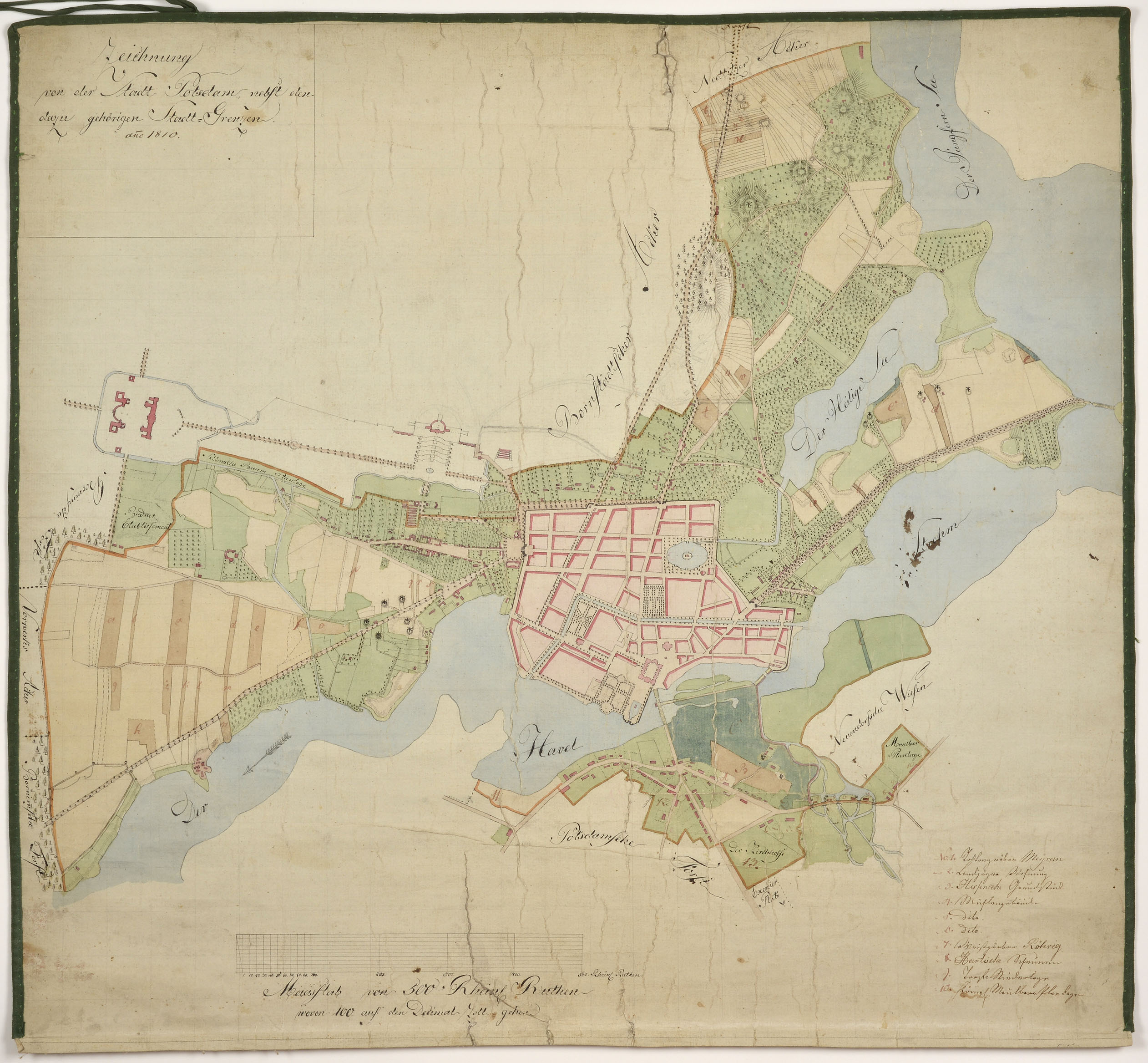
Zeichnung von der Stadt Potsdam und deren Grenzen (Potsdam Museum - Forum für Kunst und Geschichte CC BY-NC-SA)
Provenance/Rights: Potsdam Museum - Forum für Kunst und Geschichte / Michael Lüder (CC BY-NC-SA)
1 / 1 Previous<- Next->

Zeichnung von der Stadt Potsdam und deren Grenzen

Contact Cite this page Data sheet (PDF) Canonical version (record) Calculate distance to your current location Mark for comparison Graph view

Description

Wohl unvollendeter Plan der Stadt Potsdam aus dem Jahr 1810, 1963 als Schenkung in die Sammlung gelangt.

bez.:
o. li.: Zeichnung / von der Stadt Potsdam, nebst den / dazu gehörigen Stadt=Grenzen: / anno 1810.
u. li.: Masstab von 500 Rheinl. Ruthen / wovon 100 auf den Dezimal Zoll gehen.
u. re.: Legende 1-10 für Neuendorf:
No. 1. Todtengräber Meyer
2. Landjäger Wohnung
3. Hessensche Grundstück
4. Mühlengebäude
5. dito
6. dito
7. Weißgärber Röhrig
8. Hartische Scheunen
9. Torf=Niederlage
10. Königl. Maulbeerplantage

Material/Technique

Grafit, Feder, Wasserfarben, kaschiert

Measurements

57,5 x 61,7 cm (Blattmaß)

Map
Potsdam Museum - Forum für Kunst und Geschichte

Object from: Potsdam Museum - Forum für Kunst und Geschichte

Das Potsdam Museum wurde 1909 von Potsdamer Bürgern und Mäzenen, die im Potsdamer Kunstverein und Potsdamer Museumsverein aktiv waren, als...

Contact the institution

[Last update: ]

Usage and citation

The textual information presented here is free for non-commercial usage if the source is named. (Creative Commons Lizenz 3.0, by-nc-sa) Please name as source not only the internet representation but also the name of the museum.
Rights for the images are shown below the large images (which are accessible by clicking on the smaller images). If nothing different is mentioned there the same regulation as for textual information applies.
Any commercial usage of text or image demands communication with the museum.