museum-digital
CTRL + Y
en
Johann-Friedrich-Danneil-Museum Salzwedel Kartographische Werke und Pläne [K 886]
Karte der Altmark im 18. Jahrhundert mit Kreiseinteilung (Johann-Friedrich-Danneil-Museum Salzwedel CC BY-NC-SA)
Provenance/Rights: Johann-Friedrich-Danneil-Museum Salzwedel (CC BY-NC-SA)
1 / 1 Previous<- Next->

Karte der Altmark im 18. Jahrhundert mit Kreiseinteilung

Contact Cite this page Data sheet (PDF) Canonical version (record) Calculate distance to your current location Mark for comparison Graph view

Description

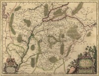
Kolorierter Kupferstich aus der 2. Hälfte des 18. Jahrhunderts mit der Einteilung der Altmark in die verschiedenen Kreise, links unten Rokokokartusche mit dem Kartentitel, rechts unten grafischer Maßstab mit Einteilung von 1/4 bis 3 Meilen, Bildrahmen mit Angaben der Himmelsrichtungen an den Bildrändern (Morgen, Mittag, Abend, Mitternacht) Kartenblatt eng beschnitten, Bez.: Die ALTE-MARCK

Material/Technique

Kupferstich, koloriert

Measurements

12,6 x 16,3 cm

Literature

  • Kalmbach, Ulrich (1994): Das Bild der Alten Marck. Die Altmark in historischen Landkarten. Salzwedel
Johann-Friedrich-Danneil-Museum Salzwedel

Object from: Johann-Friedrich-Danneil-Museum Salzwedel

Das Johann-Friedrich-Danneil-Museum ist mit seiner Gründung im Jahre 1932 eine wichtige historische Sammlungs- und Forschungsstelle in der westlichen...

Contact the institution

[Last update: ]

Usage and citation

The textual information presented here is free for non-commercial usage if the source is named. (Creative Commons Lizenz 3.0, by-nc-sa) Please name as source not only the internet representation but also the name of the museum.
Rights for the images are shown below the large images (which are accessible by clicking on the smaller images). If nothing different is mentioned there the same regulation as for textual information applies.
Any commercial usage of text or image demands communication with the museum.