museum-digital
CTRL + Y
en
Heimatmuseum und -Archiv Bad Bodendorf Ansichtskarten [3001_B_6-05]
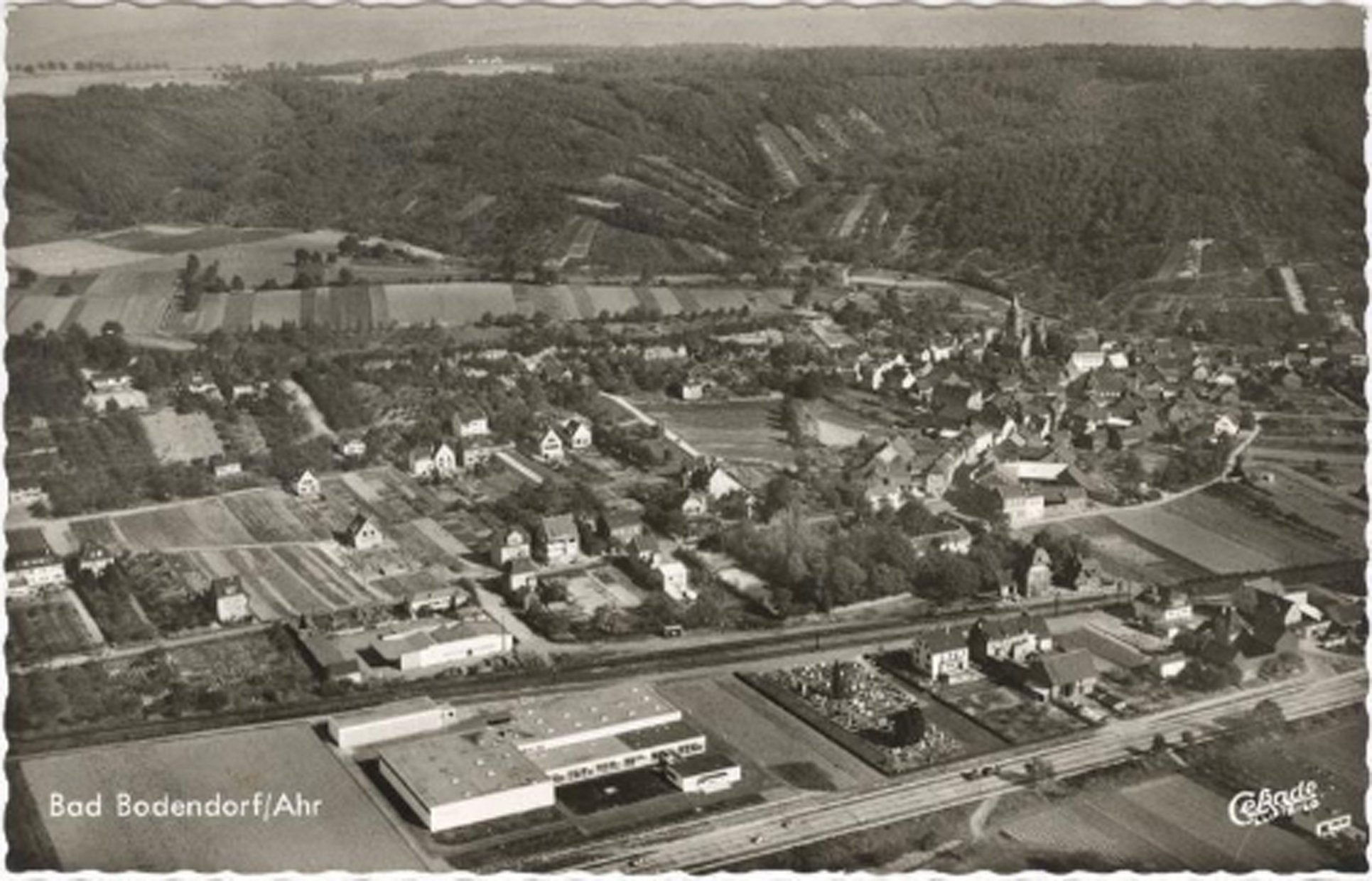
Ansichtskarte Luftbild Bad Bodendorf (Heimatarchiv Bad Bodendorf CC BY-NC-SA)
Provenance/Rights: Heimatarchiv Bad Bodendorf / Josef Erhardt (CC BY-NC-SA)
1 / 2 Previous<- Next->

Ansichtskarte Luftbild Bad Bodendorf

Contact Cite this page Data sheet (PDF) Canonical version (record) Calculate distance to your current location Mark for comparison Graph view

Description

Querformat mit gezacktem Rand und SW-Druck.
Das Bild ist im Anflug von Süden aus einer Höhe von ca. 200 m aufgenommen.
Im Vordergrung die Bundesstraße von Ost nach West verlaufend. Links die Mineralwasserfabrik Bodendorfer Sprudel, Rechts daneben Feld und anschließend der Friedhof und folgend Wohnbebauung bis Bildrand. Im Mittleren Bildfeld rechts der Ortskern und nach links in Einzelbebauung übergehend. Vor dem hinter dem Ort liegenden abfallenden Hängen sind vereinzelt noch Weinberge erkennbar.
Die Karte wurde beschriftet und nach Mönchen-Gladbach verschickt.

Material/Technique

Fotodruckkarton

Measurements

H 88 mm; B 139 mm

Heimatmuseum und -Archiv Bad Bodendorf

Object from: Heimatmuseum und -Archiv Bad Bodendorf

1990 richtete der Heimat- und Bürgerverein Bad Bodendorf das Heimatmuseum und -Archiv in einem ehemaligen Tante-Emma-Laden in der Hauptstraße 56 ein....

Contact the institution

[Last update: ]

Usage and citation

The textual information presented here is free for non-commercial usage if the source is named. (Creative Commons Lizenz 3.0, by-nc-sa) Please name as source not only the internet representation but also the name of the museum.
Rights for the images are shown below the large images (which are accessible by clicking on the smaller images). If nothing different is mentioned there the same regulation as for textual information applies.
Any commercial usage of text or image demands communication with the museum.