museum-digital
CTRL + Y
en
Museum Berlin-Karlshorst Sammlung [100370]
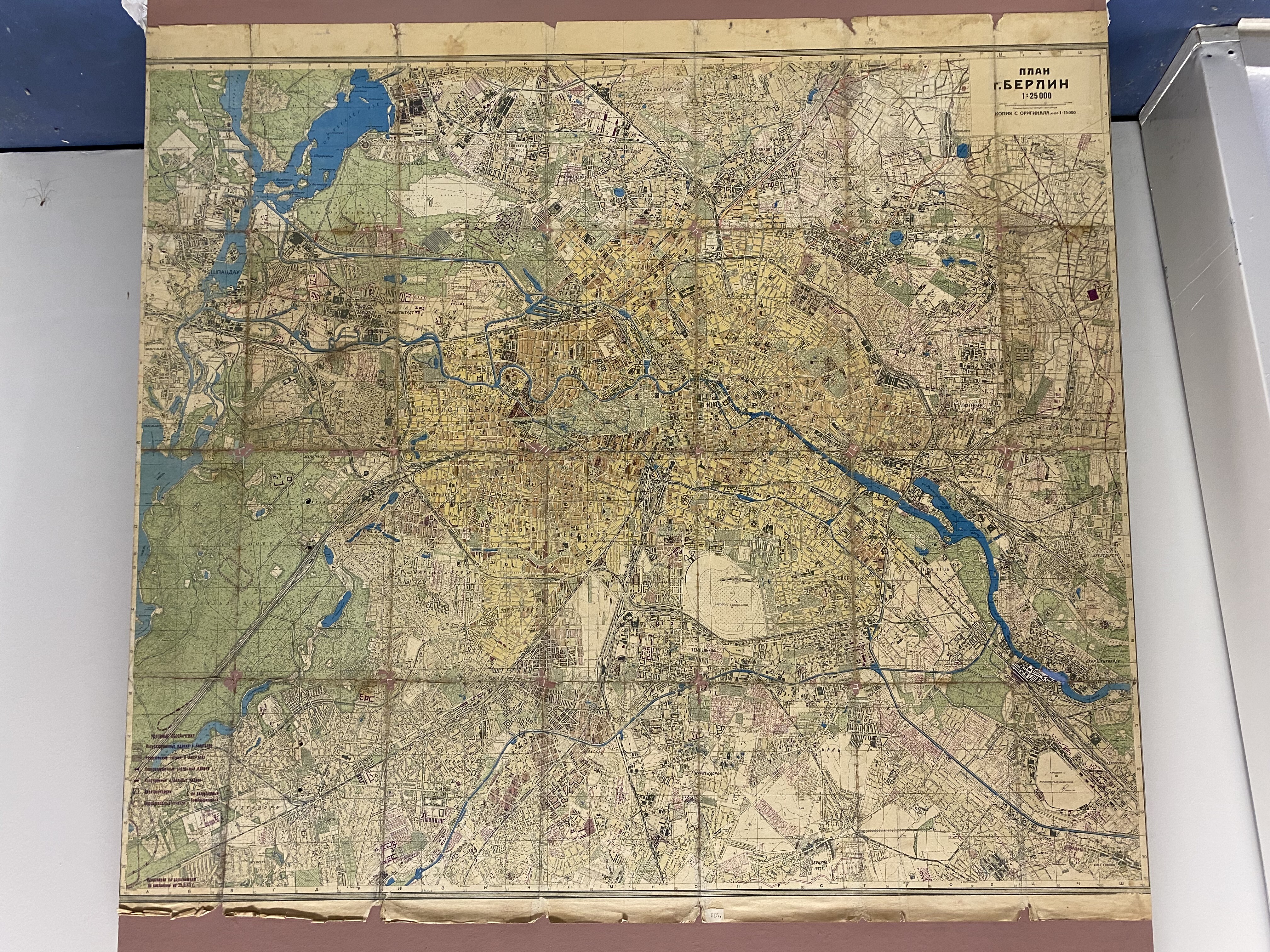
Karte von Berlin (Deutsch-Russisches Museum Berlin-Karlshorst CC BY-NC-SA)
Provenance/Rights: Deutsch-Russisches Museum Berlin-Karlshorst / Ekaterina Malygina (CC BY-NC-SA)
1 / 11 Previous<- Next->

Sowjetischer Stadtplan von Berlin, 1945

Contact Cite this page Data sheet (PDF) Canonical version (record) Calculate distance to your current location Mark for comparison Graph view

Description

Ein russischer Stadtplan von Berlin, Maßstabsbereich 1:25000. Korrekturen zum Zustand am 25.03.1945 wurden nach Luftaufnahmen gemacht. Der Zerstörungsgrad von einzelnen wichtigen Gebäuden und Stadtteilen ist mit verschiedenen Farben markiert. Auch noch unzerstörte Kraft- und Wasserwerken sind hervorgehoben. Angaben über Verteidigungseinrichtungen fehlen.

Material/Technique

Papier / gedruckt, handgeschrieben

Measurements

Höhe: 89,0 cm, Breite: 102,0 cm

Map
Created Created
1945
[Relation to time] [Relation to time]
1945
1944 1947
Museum Berlin-Karlshorst

Object from: Museum Berlin-Karlshorst

Mit dem Akt der bedingungslosen Kapitulation in unserem Haus endete der Zweite Weltkrieg in Europa. Am 8. Mai 1945 unterzeichnete das Oberkommando...

Contact the institution

[Last update: ]

Usage and citation

The textual information presented here is free for non-commercial usage if the source is named. (Creative Commons Lizenz 3.0, by-nc-sa) Please name as source not only the internet representation but also the name of the museum.
Rights for the images are shown below the large images (which are accessible by clicking on the smaller images). If nothing different is mentioned there the same regulation as for textual information applies.
Any commercial usage of text or image demands communication with the museum.